Smart GIS free Download:
https://drive.google.com/file/d/0B2qR4wxKKE_VUmR6V2hYRHRqb2c/view?usp=sharing
Suggeted Google Earth free Download:
https://drive.google.com/file/d/0B2qR4wxKKE_VUkRkeEV6NTYyT2c/view?usp=sharing
فيديوهات شرح منظومة سمارت جى اى اس Smart GIS Tutorials Videos
A Geographic Information System (GIS) is a computer program for storing, retrieving, analyzing, and displaying cartographic data.https://drive.google.com/file/d/0B2qR4wxKKE_VUmR6V2hYRHRqb2c/view?usp=sharing
Suggeted Google Earth free Download:
https://drive.google.com/file/d/0B2qR4wxKKE_VUkRkeEV6NTYyT2c/view?usp=sharing
GIS Software Programming is impacted by various sciences, which are integral to the GIS programming such as geographic, graphic, database, operating research, software engineering, software programming and code enhancement.
By applying those above mentioned sciences and techniques, to the GIS programming activities, we achieved our GIS Software.
GIS Map Editor Manual
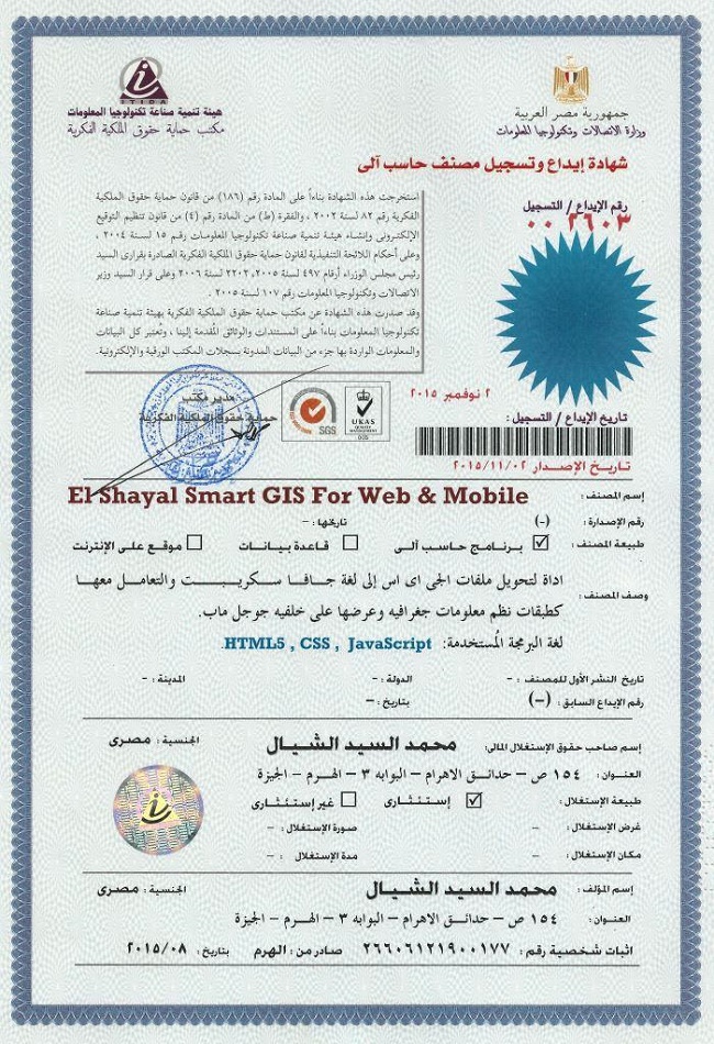
https://login.itida.gov.eg/ViewProfileFull.aspx?ID=2814
شهادات منظومة سمارت جى اى اس Smart GIS Certificates
https://drive.google.com/folderview?id=0B2qR4wxKKE_VflFBZk5mcTRneWRoTVhMLUlPTXZ6SXJuOUdfdFp6amMyQURHSlYxZUoyR0U&usp=sharing
For Free Download :-
Version 17.001 to Convert GIS Shape files to HTML Google Map Web Mapping and Mobile Application with Label and Data Base Search
https://drive.google.com/file/d/0B2qR4wxKKE_VUmR6V2hYRHRqb2c/view?usp=sharing
GIS Software Elshayal Smart GIS package is an almost First Arabian GIS software which completely developed by Arabian developers team (Mohamed Elshayal & Salsabeel Mohamed Elshayal & Yaseen Mohamed Elshayal) and independent of any commercial software package, and It is not supported or funded by any organization.

GIS Software Elshayal Smart GIS is a free lightweight software program which allows you to work with vector layers and raster images. It can be handled by users who specialize in GIS.
The interface of the application is plain and intuitive, so you shouldn't have any problems in discovering its features if you are already familiarized with similar tools.
GIS Software Elshayal Smart GIS comes equipped with some standard functions, such as zoom, pan, box selection, identify, hyper link and measure.
You can create new layers which focus on points, polylines, polygons and multiple points, as well as on combinations of these items. It is possible to automatically balance the image, go to a custom-scaled layer in Google Earth, validate layer boundaries, and edit the layer data table.
Furthermore, you can use the undo and redo functions, insert and snap vertexes, rotate or scale the image, find items by data, divide polygons or polylines, combine multiple parts into a single one, toggle 3D viewing mode, as well as calculate the area and volume of the shape, among others.
GIS Software Elshayal Smart GIS runs on a low-to-moderate quantity of CPU and system memory, has a good response time and supports keyboard shortcuts. No error dialogs have been displayed during our testing and the program did not freeze or crash. Since it integrates some advanced features,
GIS Software Elshayal Smart GIS is primarily addressed to skilled users.

https://drive.google.com/file/d/0B2qR4wxKKE_VY19hY1VKS3JFWnc/view?usp=sharing
More Information In Arabic
https://drive.google.com/file/d/0B2qR4wxKKE_VMnJQdGFUZklZSEk/view?usp=sharing
GIS Software Elshayal Smart GIS software is a GIS Standalone applications that Create & Edit & Publish Shape and Data base files and works on PC's , or Internet Server , or on Smart Phones.
It is a new software that can work directly on the digital maps installed on the device or through a communication module and it can read from GPS receivers.
it consists of Map Editor for desktop, and Map Server for web application, and Mobile GPS Tracking for mobile application and Smart Phones
For Free Download :-
Version 17.001 to Convert GIS Shape files to HTML Google Map Web Mapping and Mobile Application with Label and Data Base Search
https://drive.google.com/file/d/0B2qR4wxKKE_VUmR6V2hYRHRqb2c/view?usp=sharing

GPS provides special satellite signals, which are processed by a receiver. These GPS receivers not only track the exact location but can also compute velocity and time. The positions can even be computed in three-dimensional views with the help of four GPS satellite signals. The Space Segment of the Global Positioning System consists of 27 Earth-orbiting GPS satellites. There are 24 operational and 3 extra (in case one fails) satellites that move round the Earth each 12 hours and send radio signals from space that are received by the GPS receiver. Fleet Management Solutions
ReplyDeleteThis comment has been removed by the author.
ReplyDelete