Showing posts with label NASA ASTER. Show all posts

GIS Conversion Tools

فيديوهات شرح منظومة سمارت جى اى اس Smart GIS Tutorials Videos

GIS Conversion Tools


A)  Converting AutoCAD files to GIS Shape Files

Converting AutoCAD file to Shape Files
Menu Tools Converting AutoCAD file to Shape File

B)  Converting GIS Shape Files to AutoCAD files

Converting Shape File to AutoCAD file
Menu Tools Converting Shape File to AutoCAD file

C)  Converting GIS Shape Files to Google KML files

Converting Shape File to Google KML file
Menu Tools Converting Shape File to Google KML file

D)  Converting GIS Shape Files to HTML GIS Web Sites

Converting GIS Shape File to HTML GIS Web Sites
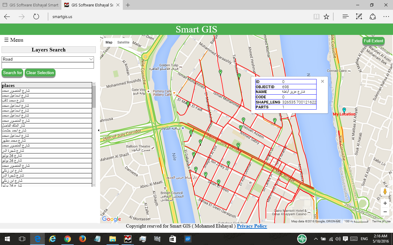
Menu Tools Converting GIS Shape File to HTML GIS Web Sites

E)  Synchronize Google Earth with Lon Lat Geographic maps

Synchronize Google Earth with Lon Lat Geographic Maps
Menu Tools Synchronize Google Earth with Lon Lat Geographic Maps
Settings
  • Open Google Earth 4.3 or Later Versions ( It must be installed in your Computer )
  • Inside Google Earth, do the following Settings
  • Tools  Options : Turn Off Terrain
  • Be Sure that North Arrow is completely very up by
    • View Show Navigation Always
    • Press Double Click on North
  • Be Sure that Google Earth is very Flat by:
    • Pressing keyboard Shift and keyboard Up Arrow.
    • Pressing Keyboard Ctrl and keyboard down arrow
  • Close Google Earth
  • Open GIS Software
  • Set Map Projection to Decimal Degree
  • Be Sure Google Earth Software is NOT maximized and is NOT Full Screen

تسجيل منظومة سمارت جى اى اس  ايتيدا  Smart GIS Registeration in ITIDA

شهادات منظومة سمارت جى اى اس Smart GIS Certificates


GIS Surface Analysis

فيديوهات شرح منظومة سمارت جى اى اس Smart GIS Tutorials Videos

A)  Downloading  (ASTER and SRTM)  NASA Geo DEM Height Files

Open your Internet browser and go to the following URL to Download ASTER Geo DEM
http://www.gdem.aster.ersdac.or.jp/search.jsp
Open your Internet browser and go to the following URL to Download SRTM height files
http://dds.cr.usgs.gov/srtm/version2_1/SRTM3/

B)  Convert (ASTER and SRTM) NASA Geo DEM Height Files to Tin Shape File

Convert (ASTER & SRTM) DEM to Tin Shape file
Menu Tools Convert (ASTER & SRTM) DEM to Tin Shape file

C)  Convert ASTER NASA Geo DEM to Color value bmp File

Convert ASTER Geo DEM to Color Value bmp file
Menu Layers Add Layer Files of Type TIFF Open
Menu Layers Save Layer as Change the File extension to BMP   Save
  • Open Aster Geo DEM Tiff file
  • Save Layer as bmp file
  • Press Identify at any point in image to get Elevation value

D)  Building Contours from ASTER NASA Geo DEM

Menu Surface Building Contours Surface(s) Analysis

E)  Building Tin Surface Analysis

Menu Surface Building Tin Surface(s) Analysis
  • Select Height Layer Name
  • Select Height Criteria (All Feature or  Inside Selected Features or Outside Selected Features)
  • Select Height Field
  • Select Output Tin Surface Shape file name
  • Select Build Surface by Delaunay, if elevation points have unequal distances among them.
  • Select Build Surface by Matrix, if elevation points have equal distances among them.
  • Press Build

F)  Building Contours Surface(s) Analysis

Building Contours Surface(s) Analysis
Menu Surface Building Contours Surface(s) Analysis
  • Check Use Height Layer as Tin Surface or Not
  • Select Height Layer Name
  • Select Height Criteria (All Feature or  Inside Selected Features or Outside Selected Features)
  • Select Height Field
  • Select Contour Interval
  • Select Base Contour
  • Select Output Contour Shape file name
  • Select Build Surface by Delaunay, if elevation points have unequal distances among them.
  • Select Build Surface by Matrix, if elevation points have equal distances among them.
  • Select Do not build Surface, if Height layer is a Tin Surface
  • Press Build


G)  Converting 2D to 3D Surface Analysis

Converting 2D to 3D Surface Analysis
Menu Surface Converting 2D to 3D Surface Analysis
  • Check Use Height Layer as Tin Surface or Not
  • Select Height Layer Name
  • Select Height Criteria (All Feature or  Inside Selected Features or Outside Selected Features)
  • Select Height Field
  • Select Destination 2D GIS Shape File
  • Select Criteria of the Destination 2D GIS Shape File
  • Select Output 3D Shape file name
  • Select Build Surface by Delaunay, if elevation points have unequal distances among them.
  • Select Build Surface by Matrix, if elevation points have equal distances among them.
  • Select Do not build Surface, if Height layer is a Tin Surface
  • Press Convert

H)  Calculating Area and Volume of Surface(s)

Calculate Area and Volume of Surface(s)
Menu Surface Calculate Area and Volume of Surface(s)
  • Check Use Height Layer as Tin Surface or Not
  • Select Height Layer Name
  • Select Height Criteria (All Feature or  Inside Selected Features or Outside Selected Features)
  • Select Height Field
  • Select Height of the Calculating Plane
  • Select above Plane or Below Plane
  • Select Build Surface by Delaunay, if elevation points have unequal distances among them.
  • Select Build Surface by Matrix, if elevation points have equal distances among them.
  • Select Do not build Surface, if Height layer is a Tin Surface
  • Press Calculate


تسجيل منظومة سمارت جى اى اس  ايتيدا  Smart GIS Registeration in ITIDA

شهادات منظومة سمارت جى اى اس Smart GIS Certificates


GIS Analysis and Selection

فيديوهات شرح منظومة سمارت جى اى اس Smart GIS Tutorials Videos

A)  Spatial Location Analysis and Selection

Selection Find and Data Transfer By Location  (Query Builder)
Menu Selection Find and Data Transfer By Location (Query Builder)
  • Select Layer Name
  • Select Criteria (All Feature or  Inside Selected Features or Outside Selected Features)
  • Select Method (New Selection or Add to Selection or Clear from Selection)
  • Select Relation
  • Select Relation  to Layer
  • Select Apply Tolerance or not
  • Select Tolerance value
  • Select Apply Data Transfer for Similar Fields Name or not
  • Select Data Transfer Fields Names
  • Press Find to Start Searching

B)  Attribute Data Base Analysis and Selection

Selection Find By Data (Query Builder)
Menu Selection Find By Data (Query Builder)
  • Select Layer Name
  • Select Criteria (All Feature or  Inside Selected Features or Outside Selected Features)
  • Select Method (New Selection or Add to Selection or Clear from Selection)
  • Select Field from the Fields List
  • Select Relation from the Relation List
  • Press Update Unique Value to get all available values
  • Select Value from the List or write it
  • Select Match Case or not
  • Select Map Scale for viewing result
  • Press Find to Start Searching the selected value  

C)  Nested Attribute Data Base Analysis and Selection

Nested Selection Find By Data (Query Builder)
Menu Selection Nested Find By Data (Query Builder)
  • Select Layer Name
  • Select Criteria (All Feature or  Inside Selected Features or Outside Selected Features)
  • Select Method (New Selection or Add to Selection or Clear from Selection)
  • Select Fields from the Fields Lists
  • Select Values
  • Select Map Scale for viewing result
  • Press Find to Start Searching the selected values

D)  Spatial Features Snapping and Dividing

Network Snap Vertexes to
Menu Network Snap Vertexes to
Menu Network Divide Polylines or Polygon on
  • Select Layer Name
  • Select Criteria (All Feature or  Inside Selected Features or Outside Selected Features)
  • Select Vertexes (All , OR (Begin & End) )
  • Select Relation
  • Select Relation  to Layer
  • Select Apply Tolerance or not
  • Select Tolerance value

E)  Shortest Path Analysis

Building Shortest Path Network
Menu Network Build Shortest Path Network
Shortest Path Network
Menu Network Shortest Path Network
  • Select Layer Name
  • Select Field Name
  • Press From Button
  • Select on the map where to start
  • Press To Button
  • Select on the Map where to Go
  • Press Run


تسجيل منظومة سمارت جى اى اس  ايتيدا  Smart GIS Registeration in ITIDA

شهادات منظومة سمارت جى اى اس Smart GIS Certificates


Featured Post

GIS Open Source