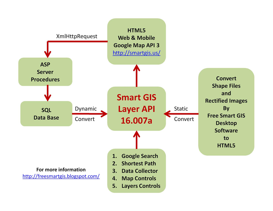
Smart GIS Layers Open Source functions
A) Menu Functions
1) ShowDiv('DivId') ;
2) HideDiv('DivId') ;
3) ClearDropDown('DivId') ;
B) XmlHttpRequest Functions
1) SendFunc('fUrl', 'fParam', 'fTarget') ;
2) SendFuncGet('fUrl', 'fParam', 'fTarget') ;
3) SendFuncPost('fUrl', 'fParam', 'fTarget') ;
4) SetSendFuncPath('Fpath') ;
5) GetFormParams('FormID') ;
C) Event Functions
1) StartTimeOutFunc('FuncName()', TimeML) ;
2) StopTimeOutFunc() ;
3) SetGMapEventFunc('MapEventFunc') ;
4) StartGpsWatch(LyrNo, 'clr', 'str', TimerInterval) ;
5) StopGpsWatch() ;
6) SetGpsMoveFunc('GpsMvFunc') ;
7) SetGpsClickFunc('GpsClkFunc') ;
8) SetGClickFunc(LyrNo, 'ClickFunc') ;
return true to open info window
9) SetGDragFunc(LyrNo, 'DragFunc') ;
D) Map Functions
1) SetGMap(MapNo, 'DivId', zom, Lat, Lng, Mtyp, scleCntrl, navigatCntrl, disableDblClickZom, scrllwhel, drggble) ;
Mtyp :
google.maps.MapTypeId.ROADMAP
google.maps.MapTypeId.SATELLITE
google.maps.MapTypeId.TERRAIN
google.maps.MapTypeId.HYBRID
2) SetGMapNo(MapNo) ;
3) SetGMapOptions(MapNo, zom, Lat, Lng, Mtyp, scleCntrl, navigatCntrl, disableDblClickZom, scrllwhel, drggble) ;
4) SetGMapFreeOptions(MapNo, 'Options') ;
5) ShowGTrafficLayer(MapNo) ;
6) HideGTrafficLayer(MapNo) ;
7) GetGmapZoom(MapNo) ;
8) GetGmapType(MapNo) ;
9) GetGmapCntrLat(MapNo) ;
10) GetGmapCntrLng(MapNo) ;
11) LoadGCookies(MapNo) ;
12) SaveGCookies(MapNo) ;
13) GetGAddressPlaces(MapNo, 'Address', LyrNo, 'DivID', 'DivHdr', 'Allclr', 'ClickClr', zom) ;
14) SetGInputSearchBox(MapNo, 'InputBoxID', LyrNo, 'DivID', 'DivHdr', 'Allclr', 'ClickClr', zom) ;
InputBoxID: the id of your Input Search box
15) getAddress('address', 'hdr', LyrNo, 'DivID', 'Allclr', 'ClickClr', zom) ;
16) SetGDirStart(LyrNo) ;
17) SetGDirEnd(LyrNo) ;
18) ShowGoogleDirection(LyrNo, 'DivId') ;
19) HideGoogleDirection(LyrNo, 'DivId') ;
20) CalcRoute(LyrNo, 'TrvMode', 'DivId') ;
TrvMode:
DRIVING
WALKING
BICYCLING
TRANSIT
21) CalcRouteWayPoints(LyrNo, WpsLyrNo, 'TrvMode', 'DivId') ;
22) getGpsPos(LyrNo, 'clr', 'str') ;
23) GetGpsLat() ;
24) GetGpsLng() ;
25) SetGpsCenter() ;
E) Layer Functions
1) GetGLayersCount() ;
2) GetGFeatsCount(LyrNo) ;
3) SetGLabelClsNm('clsNm') ;
4) SetGFeatLabelClsNm(LyrNo, id, 'LabelClsNm') ;
5) SetGLayerLabelClsNm(LyrNo, 'LabelClsNm') ;
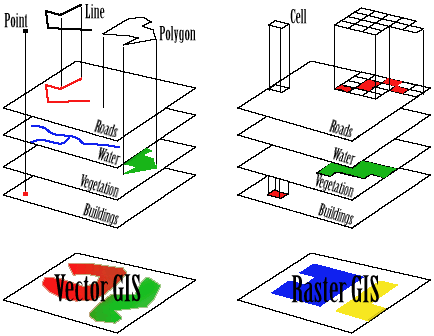
6) SetGLayer(LyrNo, GTyp) ;
GTyp :
1 for points
2 for polyline
3 for polygon
7) GetGLayerType(LyrNo) ;
8) GetGLayerMapNo(LyrNo) ;
9) SetGFeatInfo(LyrNo, id, 'cod', 'lbl', 'strokeColor', strokeOpacity, strokeWeight, 'fillColor', fillOpacity, size) ;
10) SetGLayerInfo(LyrNo, 'strokeColor', strokeOpacity, strokeWeight, 'fillColor', fillOpacity, size) ;
11) SetGPath(LyrNo, id, pth) ;
12) SetGPoint(LyrNo, id, Lat, Lng) ;
13) SetGPolyline(LyrNo, id, cntLat, cntLng) ;
14) SetGPolygon(LyrNo, id, cntLat, cntLng) ;
15) SetGImageFirstPoint(LyrNo, Lat, Lng) ;
16) SetGImageSecondPoint(LyrNo, Lat, Lng) ;
17) SetGImage(LyrNo, 'ImgSrc') ;
18) SetGInfoWinContent(LyrNo, id, 'contentStr') ;
19) SetGLayerZoom(LyrNo, Min, Max) ;
20) SetGLabelZoom(LyrNo, Min, Max) ;
21) RefreshGFeature(LyrNo, id) ;
22) IsSelectedGFeature(LyrNo, id) ;
23) SelectGFeature(LyrNo, id, 'clr') ;
24) UnSelectGFeature(LyrNo, id) ;
25) SetGMarkerCenter(LyrNo, id) ;
26) SetGFeatCenter(LyrNo, id) ;
27) SetGDraggable(LyrNo, id, TF) ;
TF: true or false
28) SetGFeatDraggable(LyrNo, id, TF) ;
TF: true or false
29) SetGLayerDraggable(LyrNo, TF) ;
TF: true or false
30) GetGClickFunc(LyrNo) ;
31) ConfirmClick(LyrNo, id) ;
32) ConfirmDrag(LyrNo, id) ;
33) CancelDrag(LyrNo, id) ;
34) FindPolygonByPoint(LyrNo, Pnt, StrtFeat) ;
35) FindFeatByCode(LyrNo, 'cod', StrtFeat) ;
36) ChangeGClrByCode(LyrNo, 'cod', 'strokeColor', strokeOpacity, strokeWeight, 'fillColor', fillOpacity, size) ;
37) FindFeatByLabel(LyrNo, 'lbl', StrtFeat) ;
38) GetLabels(LyrNo, 'lbl', hdr, 'DivID', 'Clr', zom) ;
39) SetGIcon(LyrNo, id, 'IcoSrc') ;
40) SetGFeatIcon(LyrNo, id, 'IcoSrc') ;
41) SetGLayerIcon(LyrNo, 'IcoSrc') ;
42) HideGFeatIcon(LyrNo, id) ;
43) HideGLayerIcon(LyrNo) ;
44) SetGPolylineIcon(LyrNo, id, iconSymbol, Pos) ;
45) RefreshGLayerExtend(LyrNo) ;
46) RefreshGLayer(LyrNo) ;
47) ShowGLayer(LyrNo) ;
48) HideGLayer(LyrNo, Opacity) ;
49) ShowGLayerLabel(LyrNo) ;
50) HideGLayerLabel(LyrNo) ;
51) SetGLayerExtend(LyrNo) ;
52) ZoomToGLayer(LyrNo) ;
53) UnSelectGLayer(LyrNo) ;
54) SetGfullExtend() ;
55) ZoomToAllGLayer() ;
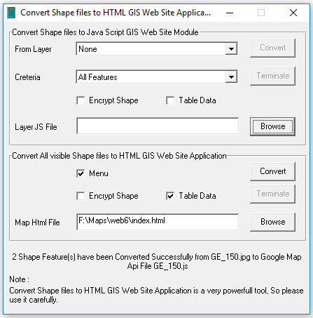
Smart GIS Open Source Code Samples
<!DOCTYPE html>
<!--HTML5 doctype-->
<html>
<head>
<meta http-equiv="Content-Type" content="text/html; charset=utf-8">
<meta http-equiv="cache-control" content="no-cache" />
<meta http-equiv="Pragma" content="no-cache">
<meta http-equiv="Expires" content="-1">
<meta name="Author" content="Mohamed Elshayal">
<title>GIS Software Elshayal Smart GIS</title>
<link rel="stylesheet" type="text/css" href="index.css">
<link rel="icon" href="https://storage.googleapis.com/mapapi/icons/favicon.ico">
<script type="text/javascript" charset="UTF-8" src="https://maps.googleapis.com/maps/api/js?key=AIzaSyBwvUThAyuM3yUnAVBRpNMUp9syAbMaWzg&libraries=places&v=3.exp&language="></script>
<script type="text/javascript" charset="UTF-8" src="https://storage.googleapis.com/mapapi/api/16007/SGapi.js" async></script>
<script type="text/javascript" charset="UTF-8" src="Road.js"></script>
<script type="text/javascript" charset="UTF-8" src="Points.js"></script>
<script type="text/javascript" charset="UTF-8">
function OnResizeFunc() {
WinWidth = (window.innerWidth || document.documentElement.clientWidth || document.body.clientWidth || screen.width);
WinHeight = (window.innerHeight || document.documentElement.clientHeight || document.body.clientHeight || screen.height);
document.getElementById(String('GoogleDiv')).style.height = String((WinHeight - 48) + 'px');
}
function OnLoadFunc() {
OnResizeFunc();
SetSendFuncPath('http://egygpstracking.com/SmartGIS/');
SetGMap(1, 'GoogleDiv', 15, 30.0647135, 31.2198430, google.maps.MapTypeId.ROADMAP, true, true, false, true, true);
SetGLabelClsNm('GoogleLabel');
try {
SetPointsGLayer(2); HideGLayerLabel(2); SetGLayerZoom(2, 1, 21); SetGLabelZoom(2, 17, 21);
SetRoadGLayer(1); HideGLayerLabel(1); SetGLayerZoom(1, 1, 21); SetGLabelZoom(1, 17, 21);
} catch (err) { }
ZoomToAllGLayer();
getGpsPos(100, '#00FFFF', 'My Location');
StartGpsWatch(100, '#00FFFF', 'My Location', 11111);
SetGInputSearchBox(1, '', 101, '', 'Places', 'Green', 'yellow', null);
ShowGTrafficLayer(1);
}
</script>
</head>
<body class="MainBody" onload="JavaScript: OnLoadFunc();" onresize="JavaScript: OnResizeFunc();">
<table class="MainLayoutTbl" style="width: 100%;">
<tr id="BodyTR" style="width: 100%;">
<td id="GoogleTD" class="GooglePrt" style="width: 100%;">
<div id="GooglePrtDiv" style="position: relative; width: 100%;">
<div id="GoogleDiv" style="width:100%; height:500px;"></div>
<div id="GoogleBtns" style="position: absolute; top: 5pt; right: 20pt; z-index: 1; direction: ltr;">
<button class="Btn" onclick="JavaScript: SetGfullExtend();" title="Full Extent">Full Extent</button>
</div>
</div>
</td>
</tr>
<tr id="FooterTR">
<td class="FooterPrt">
Copyright resrved for Smart GIS ( Mohamed Elshayal )
</td>
</tr>
</table>
</body>
</html>