فيديوهات شرح منظومة سمارت جى اى اس Smart GIS Tutorials Videos
The International Conference for Sustainable Development Future Visions for a Better Life Organized by the Faculty of Women for Arts, Science & Education Ain Shams University, Cairo - Egypt (2-3 October 2016)

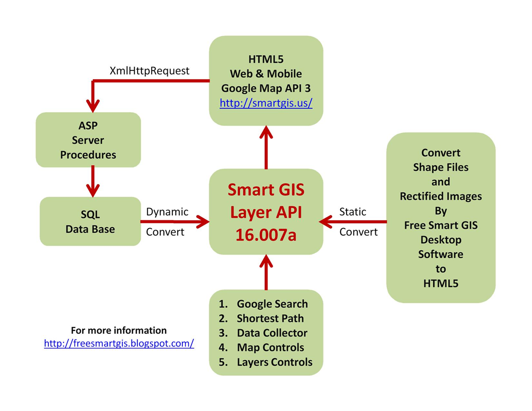
Smart GIS Software
to
Convert GIS Shape file to HTML GIS Web Site and Mobile Application
Plus
Smart GIS Layers
Open Source code
 Programmers Team
Mohamed Elshayal
Salsabeel Mohamed Elshayal & Yaseen Mohamed Elshayal
How to convert shape files to HTML
Programmers Team
Mohamed Elshayal
Salsabeel Mohamed Elshayal & Yaseen Mohamed Elshayal
How to convert shape files to HTML
-
Download the free GIS Software Elshayal Smart GIS 16.007d
https://drive.google.com/file/d/0B2qR4wxKKE_VUmR6V2hYRHRqb2c/view?usp=sharing
-
Setup it and then Run ElshayalSmart.exe
-
Open the shape files
for Example kindly download Cairo shape files and open project Cairo.arb
https://drive.google.com/file/d/0B2qR4wxKKE_VaEw4QlNkcmFZOFU/view?usp=sharing

-
Adjust Layer color:- Layer proprieties -> color

-
Adjust Layer Label : Layer proprieties -> Label

-
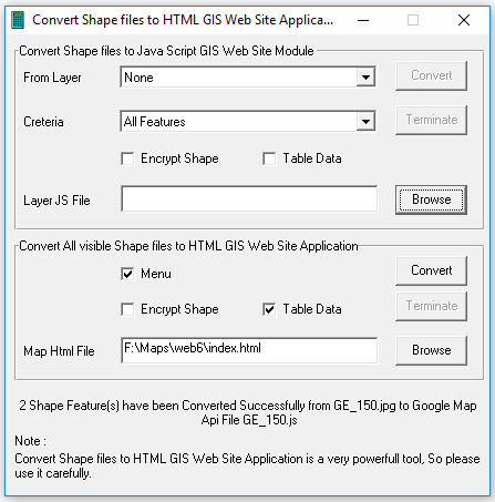
Press menu -> Tools -> convert shape files to HTML GIS web site application
-
In Convert all visible shape files to html GIS web site application frame
a. Press Browse to Select your Html5 web site target sub directory
b. Check Table Data box to assure sending attribute text data table
c. Press Convert

Smart GIS Layers Open Source functions
A) Menu Functions
return true to open info window
Mtyp :
google.maps.MapTypeId.ROADMAP
google.maps.MapTypeId.SATELLITE
google.maps.MapTypeId.TERRAIN
google.maps.MapTypeId.HYBRID
InputBoxID: the id of your Input Search box
TrvMode:
DRIVING
WALKING
BICYCLING
TRANSIT
GTyp :
1 for points
2 for polyline
3 for polygon
TF: true or false
TF: true or false
TF: true or false

Smart GIS Open Source Code Samples
<!DOCTYPE html>
<!--HTML5 doctype-->
<script type="text/javascript" charset="UTF-8" src="https://maps.googleapis.com/maps/api/js?key=AIzaSyBwvUThAyuM3yUnAVBRpNMUp9syAbMaWzg&libraries=places&v=3.exp&language="></script>
<script type="text/javascript" charset="UTF-8">
function OnResizeFunc() {
function OnLoadFunc() {

فيديوهات شرح منظومة سمارت جى اى اس Smart GIS Tutorials Videos

Download the free GIS Software Elshayal Smart GIS 16.007d
https://drive.google.com/file/d/0B2qR4wxKKE_VUmR6V2hYRHRqb2c/view?usp=sharing
https://drive.google.com/file/d/0B2qR4wxKKE_VUmR6V2hYRHRqb2c/view?usp=sharing
Setup it and then Run ElshayalSmart.exe
Open the shape files
for Example kindly download Cairo shape files and open project Cairo.arb
https://drive.google.com/file/d/0B2qR4wxKKE_VaEw4QlNkcmFZOFU/view?usp=sharing
for Example kindly download Cairo shape files and open project Cairo.arb
https://drive.google.com/file/d/0B2qR4wxKKE_VaEw4QlNkcmFZOFU/view?usp=sharing
Adjust Layer color:- Layer proprieties -> color
Adjust Layer Label : Layer proprieties -> Label
Press menu -> Tools -> convert shape files to HTML GIS web site application
In Convert all visible shape files to html GIS web site application frame
a. Press Browse to Select your Html5 web site target sub directory
b. Check Table Data box to assure sending attribute text data table
c. Press Convert
a. Press Browse to Select your Html5 web site target sub directory
b. Check Table Data box to assure sending attribute text data table
c. Press Convert
Smart GIS Layers Open Source functions
Smart GIS Open Source Code Samples
<!DOCTYPE html>
A) Menu Functions
1) ShowDiv('DivId') ;
2) HideDiv('DivId') ;
3) ClearDropDown('DivId') ;
B) XmlHttpRequest Functions
1) SendFunc('fUrl', 'fParam', 'fTarget') ;
2) SendFuncGet('fUrl', 'fParam', 'fTarget') ;
3) SendFuncPost('fUrl', 'fParam', 'fTarget') ;
4) SetSendFuncPath('Fpath') ;
5) GetFormParams('FormID') ;
C) Event Functions
1) StartTimeOutFunc('FuncName()', TimeML) ;
2) StopTimeOutFunc() ;
3) SetGMapEventFunc('MapEventFunc') ;
4) StartGpsWatch(LyrNo, 'clr', 'str', TimerInterval) ;
5) StopGpsWatch() ;
6) SetGpsMoveFunc('GpsMvFunc') ;
7) SetGpsClickFunc('GpsClkFunc') ;
8) SetGClickFunc(LyrNo, 'ClickFunc') ;
return true to open info window
return true to open info window
9) SetGDragFunc(LyrNo, 'DragFunc') ;
D) Map Functions
1) SetGMap(MapNo, 'DivId', zom, Lat, Lng, Mtyp, scleCntrl, navigatCntrl, disableDblClickZom, scrllwhel, drggble) ;
Mtyp :
google.maps.MapTypeId.ROADMAP
google.maps.MapTypeId.SATELLITE
google.maps.MapTypeId.TERRAIN
google.maps.MapTypeId.HYBRID
Mtyp :
google.maps.MapTypeId.ROADMAP
google.maps.MapTypeId.SATELLITE
google.maps.MapTypeId.TERRAIN
google.maps.MapTypeId.HYBRID
2) SetGMapNo(MapNo) ;
3) SetGMapOptions(MapNo, zom, Lat, Lng, Mtyp, scleCntrl, navigatCntrl, disableDblClickZom, scrllwhel, drggble) ;
4) SetGMapFreeOptions(MapNo, 'Options') ;
5) ShowGTrafficLayer(MapNo) ;
6) HideGTrafficLayer(MapNo) ;
7) GetGmapZoom(MapNo) ;
8) GetGmapType(MapNo) ;
9) GetGmapCntrLat(MapNo) ;
10) GetGmapCntrLng(MapNo) ;
11) LoadGCookies(MapNo) ;
12) SaveGCookies(MapNo) ;
13) GetGAddressPlaces(MapNo, 'Address', LyrNo, 'DivID', 'DivHdr', 'Allclr', 'ClickClr', zom) ;
14) SetGInputSearchBox(MapNo, 'InputBoxID', LyrNo, 'DivID', 'DivHdr', 'Allclr', 'ClickClr', zom) ;
InputBoxID: the id of your Input Search box
InputBoxID: the id of your Input Search box
15) getAddress('address', 'hdr', LyrNo, 'DivID', 'Allclr', 'ClickClr', zom) ;
16) SetGDirStart(LyrNo) ;
17) SetGDirEnd(LyrNo) ;
18) ShowGoogleDirection(LyrNo, 'DivId') ;
19) HideGoogleDirection(LyrNo, 'DivId') ;
20) CalcRoute(LyrNo, 'TrvMode', 'DivId') ;
TrvMode:
DRIVING
WALKING
BICYCLING
TRANSIT
TrvMode:
DRIVING
WALKING
BICYCLING
TRANSIT
21) CalcRouteWayPoints(LyrNo, WpsLyrNo, 'TrvMode', 'DivId') ;
22) getGpsPos(LyrNo, 'clr', 'str') ;
23) GetGpsLat() ;
24) GetGpsLng() ;
25) SetGpsCenter() ;
E) Layer Functions
1) GetGLayersCount() ;
2) GetGFeatsCount(LyrNo) ;
3) SetGLabelClsNm('clsNm') ;
4) SetGFeatLabelClsNm(LyrNo, id, 'LabelClsNm') ;
5) SetGLayerLabelClsNm(LyrNo, 'LabelClsNm') ;
6) SetGLayer(LyrNo, GTyp) ;
GTyp :
1 for points
2 for polyline
3 for polygon
GTyp :
1 for points
2 for polyline
3 for polygon
7) GetGLayerType(LyrNo) ;
8) GetGLayerMapNo(LyrNo) ;
9) SetGFeatInfo(LyrNo, id, 'cod', 'lbl', 'strokeColor', strokeOpacity, strokeWeight, 'fillColor', fillOpacity, size) ;
10) SetGLayerInfo(LyrNo, 'strokeColor', strokeOpacity, strokeWeight, 'fillColor', fillOpacity, size) ;
11) SetGPath(LyrNo, id, pth) ;
12) SetGPoint(LyrNo, id, Lat, Lng) ;
13) SetGPolyline(LyrNo, id, cntLat, cntLng) ;
14) SetGPolygon(LyrNo, id, cntLat, cntLng) ;
15) SetGImageFirstPoint(LyrNo, Lat, Lng) ;
16) SetGImageSecondPoint(LyrNo, Lat, Lng) ;
17) SetGImage(LyrNo, 'ImgSrc') ;
18) SetGInfoWinContent(LyrNo, id, 'contentStr') ;
19) SetGLayerZoom(LyrNo, Min, Max) ;
20) SetGLabelZoom(LyrNo, Min, Max) ;
21) RefreshGFeature(LyrNo, id) ;
22) IsSelectedGFeature(LyrNo, id) ;
23) SelectGFeature(LyrNo, id, 'clr') ;
24) UnSelectGFeature(LyrNo, id) ;
25) SetGMarkerCenter(LyrNo, id) ;
26) SetGFeatCenter(LyrNo, id) ;
27) SetGDraggable(LyrNo, id, TF) ;
TF: true or false
TF: true or false
28) SetGFeatDraggable(LyrNo, id, TF) ;
TF: true or false
TF: true or false
29) SetGLayerDraggable(LyrNo, TF) ;
TF: true or false
TF: true or false
30) GetGClickFunc(LyrNo) ;
31) ConfirmClick(LyrNo, id) ;
32) ConfirmDrag(LyrNo, id) ;
33) CancelDrag(LyrNo, id) ;
34) FindPolygonByPoint(LyrNo, Pnt, StrtFeat) ;
35) FindFeatByCode(LyrNo, 'cod', StrtFeat) ;
36) ChangeGClrByCode(LyrNo, 'cod', 'strokeColor', strokeOpacity, strokeWeight, 'fillColor', fillOpacity, size) ;
37) FindFeatByLabel(LyrNo, 'lbl', StrtFeat) ;
38) GetLabels(LyrNo, 'lbl', hdr, 'DivID', 'Clr', zom) ;
39) SetGIcon(LyrNo, id, 'IcoSrc') ;
40) SetGFeatIcon(LyrNo, id, 'IcoSrc') ;
41) SetGLayerIcon(LyrNo, 'IcoSrc') ;
42) HideGFeatIcon(LyrNo, id) ;
43) HideGLayerIcon(LyrNo) ;
44) SetGPolylineIcon(LyrNo, id, iconSymbol, Pos) ;
45) RefreshGLayerExtend(LyrNo) ;
46) RefreshGLayer(LyrNo) ;
47) ShowGLayer(LyrNo) ;
48) HideGLayer(LyrNo, Opacity) ;
49) ShowGLayerLabel(LyrNo) ;
50) HideGLayerLabel(LyrNo) ;
51) SetGLayerExtend(LyrNo) ;
52) ZoomToGLayer(LyrNo) ;
53) UnSelectGLayer(LyrNo) ;
54) SetGfullExtend() ;
55) ZoomToAllGLayer() ;

Smart GIS Open Source Code Samples
<!DOCTYPE html>
<!--HTML5 doctype-->
<html>
<head>
<meta http-equiv="Content-Type" content="text/html; charset=utf-8">
<meta http-equiv="cache-control" content="no-cache" />
<meta http-equiv="Pragma" content="no-cache">
<meta http-equiv="Expires" content="-1">
<meta name="Author" content="Mohamed Elshayal">
<title>GIS Software Elshayal Smart GIS</title>
<link rel="stylesheet" type="text/css" href="index.css">
<link rel="icon" href="https://storage.googleapis.com/mapapi/icons/favicon.ico">
<script type="text/javascript" charset="UTF-8" src="https://maps.googleapis.com/maps/api/js?key=AIzaSyBwvUThAyuM3yUnAVBRpNMUp9syAbMaWzg&libraries=places&v=3.exp&language="></script>
<script type="text/javascript" charset="UTF-8" src="https://storage.googleapis.com/mapapi/api/16007/SGapi.js" async></script>
<script type="text/javascript" charset="UTF-8" src="Road.js"></script>
<script type="text/javascript" charset="UTF-8" src="Points.js"></script>
<script type="text/javascript" charset="UTF-8">
function OnResizeFunc() {
WinWidth = (window.innerWidth || document.documentElement.clientWidth || document.body.clientWidth || screen.width);
WinHeight = (window.innerHeight || document.documentElement.clientHeight || document.body.clientHeight || screen.height);
document.getElementById(String('GoogleDiv')).style.height = String((WinHeight - 48) + 'px');
}
function OnLoadFunc() {
OnResizeFunc();
SetSendFuncPath('http://egygpstracking.com/SmartGIS/');
SetGMap(1, 'GoogleDiv', 15, 30.0647135, 31.2198430, google.maps.MapTypeId.ROADMAP, true, true, false, true, true);
SetGLabelClsNm('GoogleLabel');
try {
SetPointsGLayer(2); HideGLayerLabel(2); SetGLayerZoom(2, 1, 21); SetGLabelZoom(2, 17, 21);
SetRoadGLayer(1); HideGLayerLabel(1); SetGLayerZoom(1, 1, 21); SetGLabelZoom(1, 17, 21);
} catch (err) { }
ZoomToAllGLayer();
getGpsPos(100, '#00FFFF', 'My Location');
StartGpsWatch(100, '#00FFFF', 'My Location', 11111);
SetGInputSearchBox(1, '', 101, '', 'Places', 'Green', 'yellow', null);
ShowGTrafficLayer(1);
}
</script>
</head>
<body class="MainBody" onload="JavaScript: OnLoadFunc();" onresize="JavaScript: OnResizeFunc();">
<table class="MainLayoutTbl" style="width: 100%;">
<tr id="BodyTR" style="width: 100%;">
<td id="GoogleTD" class="GooglePrt" style="width: 100%;">
<div id="GooglePrtDiv" style="position: relative; width: 100%;">
<div id="GoogleDiv" style="width:100%; height:500px;"></div>
<div id="GoogleBtns" style="position: absolute; top: 5pt; right: 20pt; z-index: 1; direction: ltr;">
<button class="Btn" onclick="JavaScript: SetGfullExtend();" title="Full Extent">Full Extent</button>
</div>
</div>
</td>
</tr>
<tr id="FooterTR">
<td class="FooterPrt">
Copyright resrved for Smart GIS ( Mohamed Elshayal )
</td>
</tr>
</table>
</body>
</html>

No comments:
Post a Comment