فيديوهات شرح منظومة سمارت جى اى اس Smart GIS Tutorials Videos
http://www.youtube.com/watch?v=VhvJVWRHjUU&feature=share&list=PLiYk2HfoFlPV0ZdYbf3HeGEpmPeyZCEPW
GIS Analysis and Selection
GIS Analysis and Selection
A) Spatial Location Analysis and Selection

Selection Find and Data Transfer By Location (Query Builder)
Menu → Selection → Find and Data Transfer By Location (Query Builder)
- Select Layer Name
- Select Criteria (All Feature or Inside Selected Features or Outside Selected Features)
- Select Method (New Selection or Add to Selection or Clear from Selection)
- Select Relation
- Select Relation to Layer
- Select Apply Tolerance or not
- Select Tolerance value
- Select Apply Data Transfer for Similar Fields Name or not
- Select Data Transfer Fields Names
- Press Find to Start Searching
B) Attribute Data Base Analysis and Selection

Selection Find By Data (Query Builder)
Menu → Selection → Find By Data (Query Builder)
- Select Layer Name
- Select Criteria (All Feature or Inside Selected Features or Outside Selected Features)
- Select Method (New Selection or Add to Selection or Clear from Selection)
- Select Field from the Fields List
- Select Relation from the Relation List
- Press Update Unique Value to get all available values
- Select Value from the List or write it
- Select Match Case or not
- Select Map Scale for viewing result
- Press Find to Start Searching the selected value
C) Nested Attribute Data Base Analysis and Selection
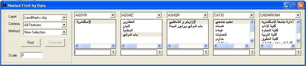
Nested Selection Find By Data (Query Builder)
Menu → Selection → Nested Find By Data (Query Builder)
- Select Layer Name
- Select Criteria (All Feature or Inside Selected Features or Outside Selected Features)
- Select Method (New Selection or Add to Selection or Clear from Selection)
- Select Fields from the Fields Lists
- Select Values
- Select Map Scale for viewing result
- Press Find to Start Searching the selected values
D) Spatial Features Snapping and Dividing
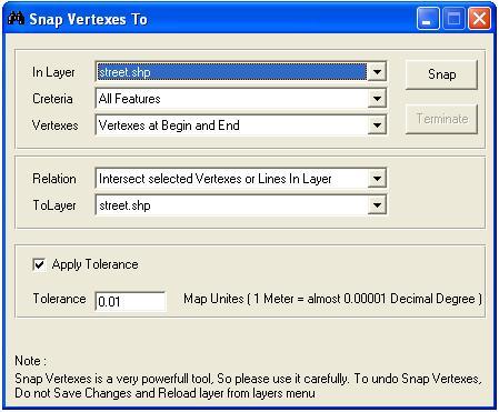
Network Snap Vertexes to
Menu → Network → Snap Vertexes to
Menu → Network → Divide Polylines or Polygon on
- Select Layer Name
- Select Criteria (All Feature or Inside Selected Features or Outside Selected Features)
- Select Vertexes (All , OR (Begin & End) )
- Select Relation
- Select Relation to Layer
- Select Apply Tolerance or not
- Select Tolerance value
E) Shortest Path Analysis
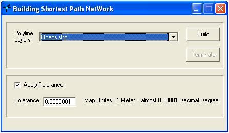
Building Shortest Path Network
Menu → Network → Build Shortest Path Network

Shortest Path Network
Menu → Network → Shortest Path Network
- Select Layer Name
- Select Field Name
- Press From Button
- Select on the map where to start
- Press To Button
- Select on the Map where to Go
- Press Run
تسجيل منظومة سمارت جى اى اس ايتيدا Smart GIS Registeration in ITIDA
شهادات منظومة سمارت جى اى اس Smart GIS Certificates

No comments:
Post a Comment