Smart GIS free Download:
Suggested Google Earth free Download:
http://www.youtube.com/watch?v=O0C3rUuqXr4&feature=share&list=PLiYk2HfoFlPV0ZdYbf3HeGEpmPeyZCEPW
Looking for Sponsors to The First African Arabian Egyptian GIS and GPS Software
Looking for Sponsors to The First African Arabian Egyptian GIS and GPS Software
First African Arabian Egyptian GIS Software Basic Functions
- Map Editing and Digitizing
- Convert GIS Shape to AutoCAD DXF File and Vise versa
- Building Tin Surface Analysis
- Building Contour Surface Analysis
- Converting 2D to 3D Surface Analysis
- Calculating 2D and 3D Areas and Volumes
- Convert Vector and Raster Layer Coordinates System between UTM and Geographic Lon-Lat
- Save layout images with written Lon and Lat coordinates to help exporting them to AutoCAD
- Download and save Google Earth Images as rectified images with world file format .jgw
- Makes Google Earth as a Background of your GIS Geographic Lon-Lat Map
Menu->Tools->Synchronize Google Earth with Geographic Lon-Lat Map - Convert and use all Transverse Mercator Projections & Transformations
- Convert GIS Shape files to HTML Google Map Web Mapping and Mobile Application
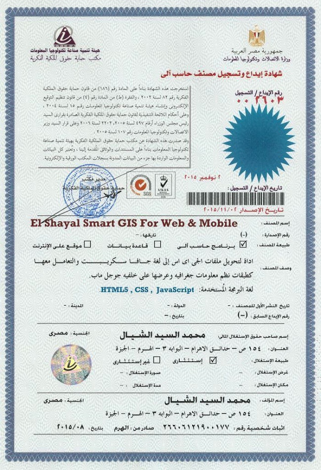
تسجيل منظومة سمارت جى اى اس ايتيدا Smart GIS Registeration in ITIDA
شهادات منظومة سمارت جى اى اس Smart GIS Certificates
For Free Download :-
Version 17.001 to Convert GIS Shape files to HTML Google Map Web Mapping and Mobile Application with Label and Data Base Search
And kindly please test our online example of automatically build HTML5 web site by Smart GIS Software http://smartgis.us/
Example of Mobile Application
https://play.google.com/store/apps/details?id=com.freesmartgisgmail.com.gpstrackingmap
https://play.google.com/store/apps/details?id=com.freesmartgisgmail.com.SmartGISGPSSoftware
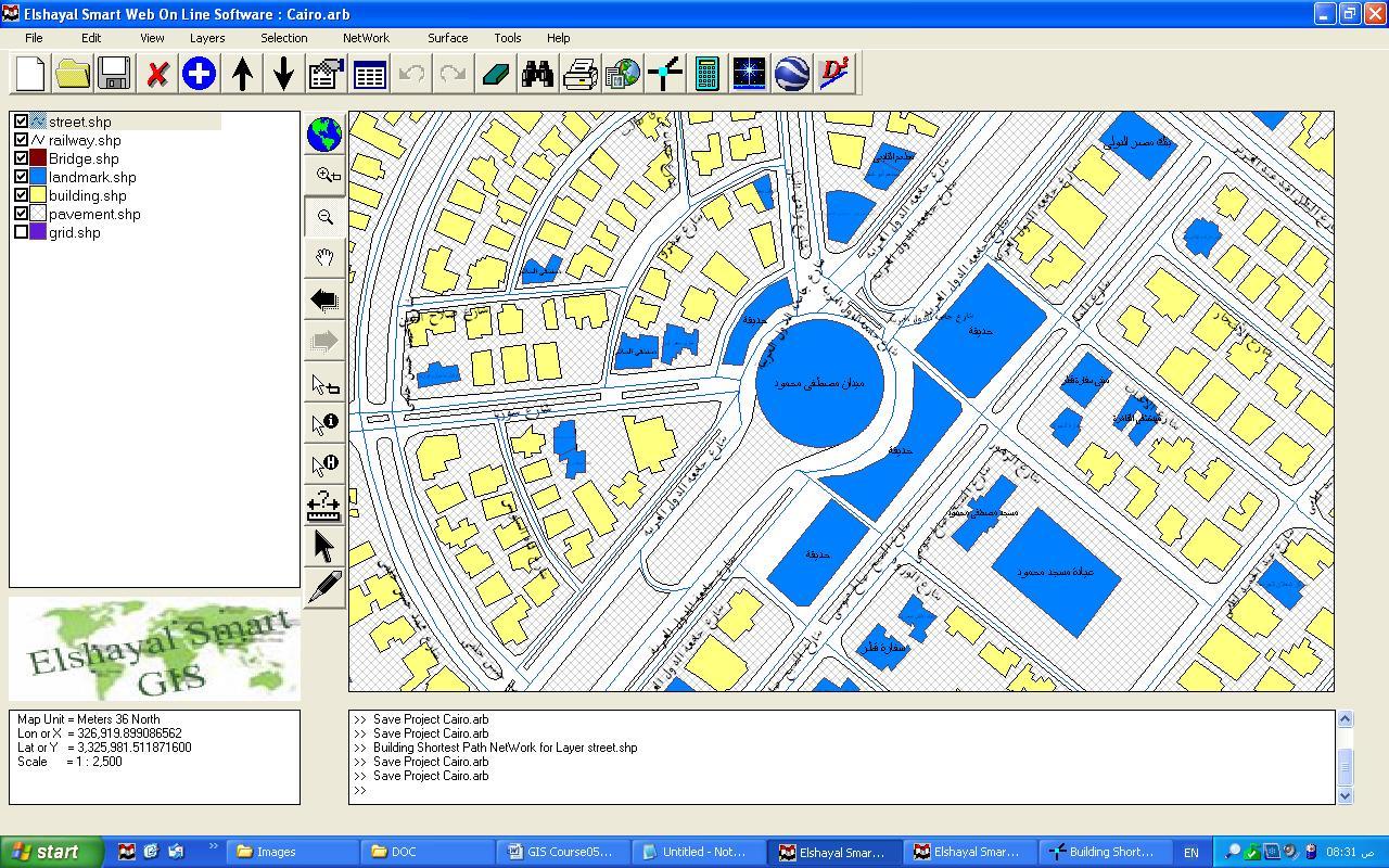
GIS Software Elshayal Smart GIS package is an almost First African Arabian Egyptian GIS software which completely developed by Arabian Egyptian developers team (Mohamed Elshayal & Salsabeel Mohamed Elshayal & Yaseen Mohamed Elshayal) and independent of any commercial software package, and It is not supported or funded by any organization.

GIS Software Elshayal Smart GIS is a free lightweight software program which allows you to work with vector layers and raster images. It can be handled by users who specialize in GIS.
The interface of the application is plain and intuitive, so you shouldn't have any problems in discovering its features if you are already familiarized with similar tools.
GIS Software Elshayal Smart GIS comes equipped with some standard functions, such as zoom, pan, box selection, identify, hyper link and measure.
You can create new layers which focus on points, polylines, polygons and multiple points, as well as on combinations of these items. It is possible to automatically balance the image, go to a custom-scaled layer in Google Earth, validate layer boundaries, and edit the layer data table.
Furthermore, you can use the undo and redo functions, insert and snap vertexes, rotate or scale the image, find items by data, divide polygons or polylines, combine multiple parts into a single one, toggle 3D viewing mode, as well as calculate the area and volume of the shape, among others.
GIS Software Elshayal Smart GIS runs on a low-to-moderate quantity of CPU and system memory, has a good response time and supports keyboard shortcuts. No error dialogs have been displayed during our testing and the program did not freeze or crash. Since it integrates some advanced features,
GIS Software Elshayal Smart GIS is primarily addressed to skilled users.

More Information In English
More Information In Arabic
GIS Software Elshayal Smart GIS software is a GIS Standalone applications that Create & Edit & Publish Shape and Data base files and works on PC's , or Internet Server , or on Smart Phones.
It is a new software that can work directly on the digital maps installed on the device or through a communication module and it can read from GPS receivers.
it consists of Map Editor for desktop, and Map Server for web application, and Mobile GPS Tracking for mobile application and Smart Phones
For Free Download :-
Version 17.001 to Convert GIS Shape files to HTML Google Map Web Mapping and Mobile Application with Label and Data Base Search
Introduction
A) Q. What is a Geographic Information System?
A. Geographic Information System (GIS) is a computer program for storing, retrieving, analyzing, and displaying cartographic data.
Vector Spatial Location Data = X, Y, Z
Attribute Data Base = Data Information
B) The Difference between Raster and Vector Maps
Maps in Geographic Information Systems are represented thematically. A standard topographic map will show roads, rivers, contour elevations, vegetation, human settlement patterns and other features on a single map sheet. In a GIS these features are categorized separately and stored in different map themes or overlays. For example, roads will be stored in a separate overlay. Likewise, rivers and streams will each be stored as a separate theme. This way of organizing data in the GIS makes maps much more flexible to use since these themes can be combined in any manner that is useful. The following illustration shows conceptually how maps are stored as themes in a GIS.
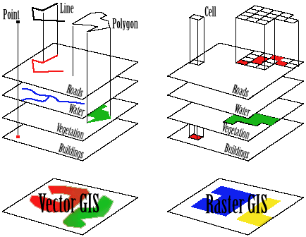
Each different theme is stored on a separate overlay. The overlays on the left represent a vector based GIS, where the information is stored as a series of points, lines and polygons. The overlays on the right represent a raster based GIS, where the information is stored as a series of discrete units called cells.
C) The Relation between Vector Spatial Location and Attribute Data Base
- Each Spatial Layer is consist of many Spatial features
- Each Spatial Feature consist of many vertexes (x, y, z)
- Each Spatial Layer is related to one Attribute Data Base Table
- Each Spatial Feature is related to one Attribute Data Base Record
- Each Record consist of many fields (up to 255)
D) GIS Shape File types 2D & 3D (Point – Polyline – Polygon)
- Shp file contain spatial Location data of each feature Which are:-
- Type 2D & 3D (Point – Polyline – Polygon)
- Number of Parts
- Number of Vertexes
- X,Y, and Z of each vertex
- Dbf file contain Attribute Data
- Each Attribute Data table consist of many records
- Each record consist of many fields (up to 255)
- Shx file is a relation file between the Shp file and Dbf fie
- Point Layer consist of one vertex per Feature(x, y, z)
- Polyline Layer consist of many vertexes per Feature
- Polygon Layer consist of many vertexes per Feature and closed
2) Coordinates Systems
A) Lon and Lat Geographic Coordinate System
The geographic latitude (abbreviation: Lat., or phi) of a point on the Earth's surface is the angle between the equatorial plane and a line that passes through that point
The North Pole is 90° N; the south pole is 90° S. The 0° parallel of latitude is designated the equator, the fundamental plane of all geographic coordinate systems. The equator divides the globe into Northern and Southern Hemispheres.
The Longitude (abbreviation: Long., or lambda) of a point on the Earth's surface is the angle east or west from a reference meridian to another meridian that passes through that point.
All meridians are halves of great ellipses (often improperly called great circles), which converge at the north and south poles.
B) Universal Transverse Mercator Coordinate System UTM
The UTM system divides the surface of Earth between 80°S and 84°N latitude into 60 zones, each 6° of longitude in width and centered over a meridian of longitude. Zone 1 is bounded by longitude 180° to 174° W and is centered on the 177th West meridian. Zone numbering increases in an easterly direction.
Each of the 60 longitude zones in the UTM system is based on a transverse Mercator projection, which is capable of mapping a region of large north-south extent with a low amount of distortion. By using narrow zones of 6° (up to 800 km) in width, and reducing the scale factor along the central meridian by only 0.0004 to 0.9996 (a reduction of 1:2500), the amount of distortion is held below 1 part in 1,000 inside each zone. Distortion of scale increases to 1.0010 at the outer zone boundaries along the equator.
C) Converting Coordinates Between Lon Lat and UTM
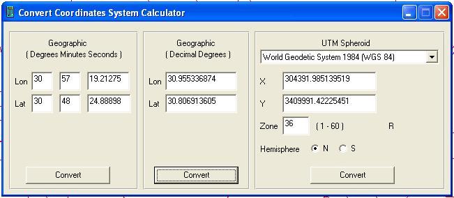
Converting Coordinates System Calculator
D) Map Projection
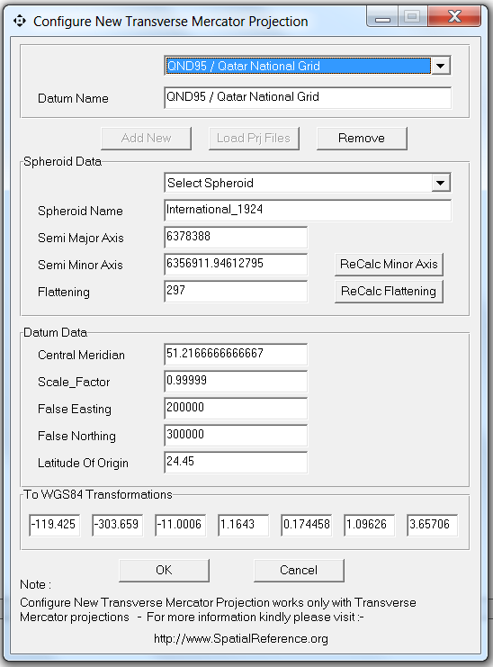
Configuring new Projection System
Menu → Tools → Configure New Projection System
- Load Projection File
- Add
- Remove
- Semi Major Axis
- Semi Minor Axis
- Flattening value
- Central Meridian
- False Easting
- False Northing
- Latitude of Origin
- To WGS84 Transformation
- http://www.SpatialReference.org
- Predefined Spheroid
- AA Airy 1930
- AN Australian National
- BR Bessel 1841 Ethiopia Indonesia Japan Korea
- BN Bessel 1841 Nambia
- CC Clarke 1866 (NAD 1927)
- CD Clarke 1880
- EB Everest Brunei & E. Malasia (Sabah & Sarawak)
- EA Everest India 1830
- EC Everest India 1956
- EF Everest Pakistan
- EE Everest W. Malasia and Singapore 1948
- ED Everest W. Malasia 1969
- RF Geodetic Reference System 1980 (NAD 1983)
- HE Helmert 1906
- HO Hough 1960
- ID Indonesian 1974
- IN International 1924
- KA Krassovsky 1940
- AM Modified Airy
- FA Modified Fischer 1960 (South Asia)
- SA South American 1969
- WD World Geodetic System 1972 (WGS 72)
- WE World Geodetic System 1984 (WGS 84)


Parking Management Software
ReplyDeleteonline parking software
Cloud based parking solutions
Free Parking Software for Town Houses, Condominiums, and Businesses Solves Parking Problems
Searching for a parking space is such as frustrating routine activity for lots of people in cities all over the world. This search is burning over a million barrels of oil of the world each day. There are also 4-parking spaces every vehicle in the US and almost all streets are most of the time, empty, which leads to urban environments that are ironically doing far more to accommodate the vehicles than people. As the global population continuously urbanize, without a convenience-driven and well-planned retreat from cars, these sort of parking problems will worsen.
http://webparkingsoftware.com software is the first step in the right decision. It involves using low-cost sensors, mobile phone-enabled, and real time data collection automated payment systems enabling people to reserve parking in advance or predict accurately where they can find a spot. When deployed as a system, free parking software thereby reduces car emissions in the urban centers by means of reducing the necessity for the people to circle the city blocks needlessly searching for parking. Furthermore, it permits the cities to manage their parking supply carefully.
This free parking software is now being developed in many different states and cities around the United States and some other countries. For instance, in LA, smart meters and low-power sensors are tracking the occupancy of parking spaces across the Hollywood district, one of the most congested areas. The users will be able to access this occupancy data in order to determine the availability of the spots and then pay for them with their mobile phones. Other than the environmental benefits and lending convenience, free parking software is improving the utilization of the current parking, which lead to greater revenue for parking owners.
These programs will be able to make great differences on a neighborhood level, but more widespread development and deployment is necessary for free parking software to change the cities and to contribute to the transportation sector pollution reductions greenhouse gas. One problem is that there are no citywide solutions all over the fragmented private and public parking providers. The occupancy data has a tendency to have many owners and is not accessible or standardized in a way that may enable software developers to turn into user-friendly applications. Thereby, individual smart parking efforts are so far successful locally, but uncoordinated, and operates in their own entrepreneurial or bureaucratic vacuums without a need to take gap between current free parking software and more widespread transportation system planning is an enormous missed opportunity for the cities to reduce the transportation related emissions.
Moreover, free parking software has been hindered by a lack of insight into the complete benefits of this software, specifically when compared to the cost of building extra parking spaces. Lack of collaboration between communities with the parking software programs, as well as lack of coordination between hardware providers, municipalities, and developers is also contributing to the slower adoption of smart parking. Nevertheless, it is possible to overcome all these issues. Cities will be able further accelerate these advantages by means of updating the land use and building codes policies to reflect the reduced need for parking.
Kindly please support and re-share First African Arabian Egyptian GIS GPS Tracking Google Map Mobile application
Deletehttps://play.google.com/store/apps/details?id=com.freesmartgisgmail.com.gpstrackingmap
All right this YouTube video is much improved than last one, this one has fastidious picture feature as well as audio.
ReplyDeleteEcommerce website design
Dear my GIS friend,
DeleteKindly please support and re-share First African Arabian Egyptian GIS Software That
Convert GIS Shape files to HTML Google Map Web GIS and Mobile Application video
https://youtu.be/O0C3rUuqXr4?list=PLiYk2HfoFlPV0ZdYbf3HeGEpmPeyZCEPW
and
kindly Please test Corrected water network example http://smartgis.us/water/01/
Thank you
Most of the blogs pretend themselves as most usable and updated blogs with new information but sometime truth might different. I want to share some facts related to this subject which will help people to enhance their skills. WorkflowMax
ReplyDeleteKindly please support and re-share First African Arabian Egyptian GIS GPS Tracking Google Map Mobile application
Deletehttps://play.google.com/store/apps/details?id=com.freesmartgisgmail.com.gpstrackingmap
Kindly please support and re-share First African Arabian Egyptian GIS GPS Tracking Google Map Mobile application
ReplyDeletehttps://play.google.com/store/apps/details?id=com.freesmartgisgmail.com.gpstrackingmap
I made a not too bad endeavor to get imply about how I could show substance of this blog. I should state, not much intense yet rather I surrendered each one of my weapons not long after subsequent to understanding it.Dell WinServ 2016 Datacenter 16C
ReplyDelete
ReplyDeleteVery nice article & have great information.
Microsoft Server 2016 Installation
ReplyDeleteIt's really awesome post. Your blog is really useful for me. Keep update your blog.
Microsoft Server 2016 Migration
Microsoft Server 2016 Repair
Guest parking software
ReplyDeleteIs the small parking space intended for guest not enough? Does it make the guest annoyed every time they try to visit in certain home? Make plans for this to avoid any consequences when dealing with guests and these are guests that should be treated well.
This software that involves specifically guests guides them on how they will handle their parking spaces. The parking spaces are not only intended for one’s convenience but they can also share their parking spaces to their guests. Some of them enter in guest parking software that will help them with their parking. The software is designed to minimize the parking spaces of every guest whether the property of someone is very small. Since the property space is small, the software is the key to this problem. Security and safe measures are customized with this software which reduces the possibility of a big disaster. Successful parking management between guests needed enhanced skills to make complex things easy. In order to obtain this, this software in innovative in which every time guests wanted to park in small or even large parking spaces. This software is powerful and always online which is easy to connect and use the system.
But how can they easily get this software? Every process comes up with steps but guest can easily create the guest parking software because today’s knowledge of people when it involves technology ensures to be modernized and available all the time. The quick response of controllers of this software tells that they are well trained and long in the business in providing and effective parking management between guests. They are always set to solve issues involving guest parking spaces. What really crazy is, common parking spaces is visualizing on first come, first serve basis. But tracking devices installed in the software facilitates in helping the guests to make reservation for parking. The parking management for guest runs with guest parking software. Guests can make an outline on how they are going to handle certain instances of parking management. Looking at parking management with manageable parking spaces is delightful in the eyes of every guest.
For suitable solution of the problems encountered by guests when parking in malls, small establishments or even hotels, certain process or steps increases the security of every guests who wishes to park in that area. The motive of this is to place the parking spaces in a setting with quick and manageable efforts. Originally, guest parking software comes with wireless connection wherein they speak to command the software on how they will park easily and smoothly. The requested command of the guests upon parking immediately delivers through the system of the software to quickly response to the needs of the guests and all information are delivered through the system. The population of car owners are wide and endless, with this, it involves bringing to life the software, which is guest parking software that caters and process on providing the guests on how they will park without problem.
Site: www.webparkingsoftware.com
Parking software condominium
Special event parking software
ReplyDeleteSoftware is used generally by people who are professionals in handling technology such as computers and other modern technology. Technology today is common to all and everyone is not denying that fact. It is not only used for better communication but in almost anything to make people’s lives easy. Among these is in parking, especially in high-volume events.
With new software in organizing, tracking and monitoring an event’s parking, you no longer need to worry about bringing your own vehicle. This is due to automated management of parking spaces with the use of software. Parking spaces, whether big or small are needed for car owners because they strive to park in their convenient time. Certain establishments own large parking spaces but different problem occurs because of the possibility of endless car owners bringing their own cars in certain places. This software serves enforcement to all car owners who wanted to access in an event is called the special event parking software. This software expertly provides high and dignified solution between customers who are in the state of parking crisis when they are in an event. It listens and provides a unified solution every time the customers requested it. They can easily install or get the software immediately in which the parking management should uphold the excellence with the customer. Considering special events, the software is needed to sustain manageable parking spaces between customers.
A tracking device is installed on special event parking software that is used to command or coordinate with the parking spaces when certain events or occasions happen. If a problem occurs in an event, it results to poor and unorganized event organizer which causes for them to shut down software or postponed said events. Following this, others will be tempted to visit or enjoy to different events. Occasionally, hotels, restaurants and other establishments offer to organize events or parties in their parking spaces which different kind of personalities are frequently joining. In the event, the parking space of the said establishments has big parking space for the event. It is not a problem but how about the small establishments, who organize a party but contains small space, special event parking software is ready to help.
Events are operated by agencies or organizers which they wanted to support and provide their customers with worthwhile and great parking space. Their main goal is to gain a successful and perfect event in that parking spaces they choose. The positive impression of special event parking software is to provide their customers how to make parking management successful. Supervising parking space to make it more conducive for organizing or hosting special events is very difficult but maintaining parking spaces is a different idea. In maintaining such one, special event parking software is taking the action providing harmonious and efficient positive results at the end. Different procedures should be followed and must be taking into consideration the various strategies on how to make smaller parking spaces become bigger. Site: www.webparkingsoftware.com
email blast to tenants
Guest parking
Gracefully written information on this blog are going to support me for my coming assignments. Every point was very clear and taught me few new parameters. I would like to use this information in coming future.
ReplyDeleteHPE ProLiant DL360 Gen9
We take the frustration out of parking management for Apartments, Home Owners Associations, Condominiums, Townhouses Co-ops, and other parking areas. Webparkingsoftware.com has reinvented how parking management should be done.
ReplyDeleteemail blast to tenants
Guest parking
Before downloading ibomma telugu movies in 2022, you have to know
ReplyDeletewhat is consignment number in India Post
الدكتور أحمد عبد السلام استشاري ومحاضر شهير في الجراحة العامة وجراحات المناظير والسمنة المفرطة. يعتبر أفضل طبيب في هذا المجال ولديه سنوات من الخبرة في عملية تكميم المعدة فى مصر يعمل مع جامعة تكميم المعدة ويقدم عمليات جراحية مثل عمليات الفتق بالمنظار وعمليات التحويل وعمليات الفتق. إن خبرته في طب إنقاص الوزن والعمليات الجراحية بالمنظار مطلوبة بشدة، ومن المؤكد أن مرضاه سيحصلون على أفضل رعاية ممكنة. وهو معروف بكونه جراح السمنة المشهور على الإنترنت ويوصى به بشدة نظرًا لمعدلات سلامته. الدكتور أحمد عبد السلام هو الخيار الأمثل لأي شخص يتطلع لإجراء عملية تكميم المعدة في مصر.
ReplyDeleteSecure your car with Spy World's GPS tracker for car. Keep your vehicle safe and monitor its location in real-time. Order now for peace of mind! For any query: Call us at 8800809593 | 8585977908.
ReplyDeleteAxcel Gases is a well-known synthetic air gas cylinder manufacturer in India. We provide good quality gas cylinders filled with synthetic air. Our cylinders are safe, tested, and used in many industries for different works. Contact now.
ReplyDelete