Smart GIS Map Editor free Download:
Suggested Google Earth 7.1.7 Direct Download:
https://drive.google.com/file/d/0B2qR4wxKKE_VUkRkeEV6NTYyT2c/view?usp=sharing
فيديوهات شرح منظومة سمارت جى اى اس Smart GIS Tutorials Videos
http://www.youtube.com/watch?v=O0C3rUuqXr4&feature=share&list=PLiYk2HfoFlPV0ZdYbf3HeGEpmPeyZCEPW
Looking for Sponsors to The First African Arabian Egyptian GIS and GPS Software that convert GIS Shape File to HTML Google Map Web GIS and Mobile Application
Smart Web GIS Course Syllabus
http://freesmartgis.blogspot.com.eg/p/convert-gis-to-html.html
- Theoretical GIS
- HTML5 & CSS & JS Programming
- Smart GIS API and Google Map API Programming
- Building Web GIS Based Application
- Server Data Base Programming by ASP
- Building Web GIS Based Mobile Application
In this course the trainees will learn by using Smart GIS Layer API code library and template :-
- How to convert GIS shape file layer to HTML5 and JS Web GIS and Google map API file format
- How to build HTML5 + Java Script + CSS web GIS App.
- How to use Smart GIS API functions to control Web GIS
- How to connect database and retrieve results
- How to use ASP to connect Database and retrieve data and draw it in the Google map API
- How to use all of the above mentioned skills to build a mobile application
First African Arabian Egyptian GIS Software Basic Functions
- Map Editing and Digitizing
- Convert GIS Shape to AutoCAD DXF File and Vise versa
- Building Tin Surface Analysis
- Building Contour Surface Analysis
- Converting 2D to 3D Surface Analysis
- Calculating 2D and 3D Areas and Volumes
- Convert Vector and Raster Layer Coordinates System between UTM and Geographic Lon-Lat
- Save layout images with written Lon and Lat coordinates to help exporting them to AutoCAD
- Download and save Google Earth Images as rectified images with world file format .jgw
- Makes Google Earth as a Background of your GIS Geographic Lon-Lat Map
Menu->Tools->Synchronize Google Earth with Geographic Lon-Lat Map
- Convert and use all Transverse Mercator Projections & Transformations
- Convert GIS Shape files to HTML Google Map Web Mapping and Mobile Application
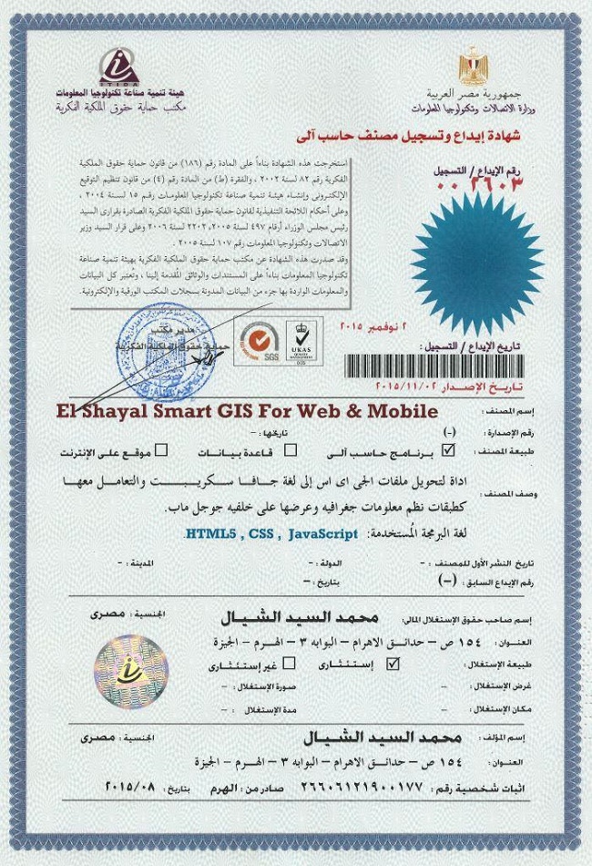
تسجيل منظومة سمارت جى اى اس ايتيدا Smart GIS Registeration in ITIDA
شهادات منظومة سمارت جى اى اس Smart GIS Certificates
For Free Download :-
Smart GIS Map Editor and Analysis and Downoad Google Earth Maps and Convert GIS Shape files to HTML Google Map Web Mapping and Mobile Application with Label and Data Base Search
And kindly please test our online example of automatically build HTML5 web site by Smart GIS Software http://smartgis.us/
Example of Mobile Application
https://play.google.com/store/apps/details?id=com.freesmartgisgmail.com.gpstrackingmap
https://play.google.com/store/apps/details?id=com.freesmartgisgmail.com.SmartGISGPSSoftware
GIS Software Elshayal Smart GIS package is an almost First African Arabian Egyptian GIS software which completely developed by Arabian Egyptian developers team (Mohamed Elshayal & Salsabeel Mohamed Elshayal & Yaseen Mohamed Elshayal) and independent of any commercial software package, and It is not supported or funded by any organization.

GIS Software Elshayal Smart GIS is a free lightweight software program which allows you to work with vector layers and raster images. It can be handled by users who specialize in GIS.
The interface of the application is plain and intuitive, so you shouldn't have any problems in discovering its features if you are already familiarized with similar tools.
GIS Software Elshayal Smart GIS comes equipped with some standard functions, such as zoom, pan, box selection, identify, hyper link and measure.
You can create new layers which focus on points, polylines, polygons and multiple points, as well as on combinations of these items. It is possible to automatically balance the image, go to a custom-scaled layer in Google Earth, validate layer boundaries, and edit the layer data table.
Furthermore, you can use the undo and redo functions, insert and snap vertexes, rotate or scale the image, find items by data, divide polygons or polylines, combine multiple parts into a single one, toggle 3D viewing mode, as well as calculate the area and volume of the shape, among others.
GIS Software Elshayal Smart GIS runs on a low-to-moderate quantity of CPU and system memory, has a good response time and supports keyboard shortcuts. No error dialogs have been displayed during our testing and the program did not freeze or crash. Since it integrates some advanced features,
GIS Software Elshayal Smart GIS is primarily addressed to skilled users.

More Information In English
More Information In Arabic
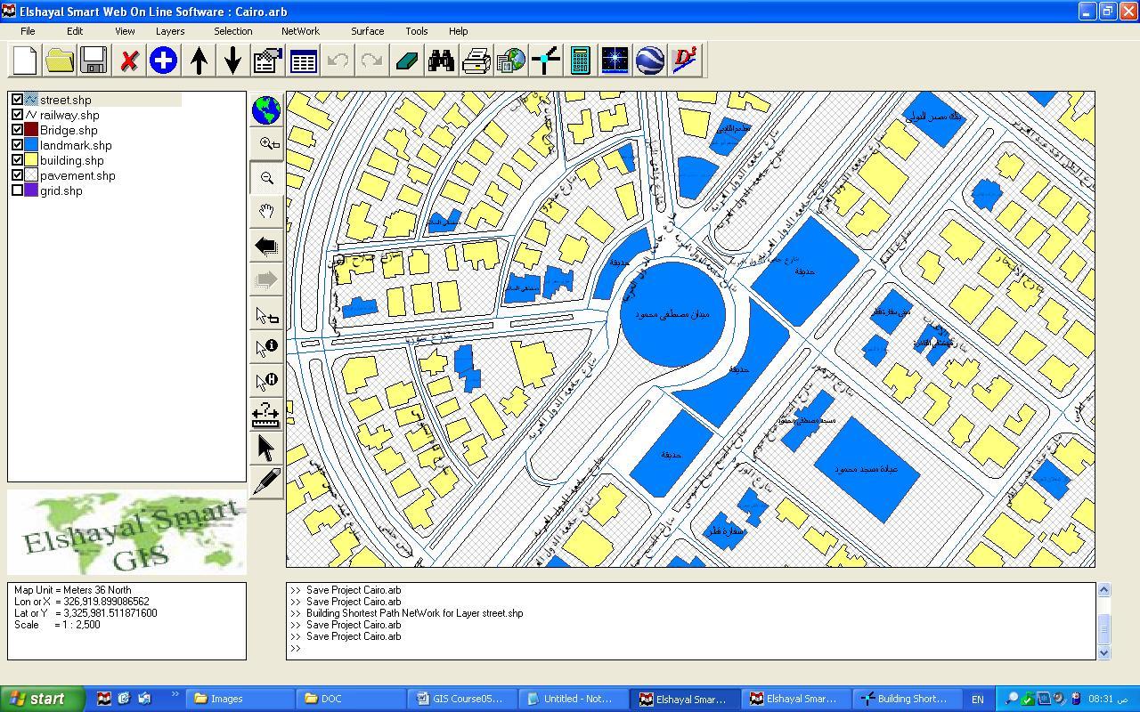
GIS Software Elshayal Smart GIS software is a GIS Standalone applications that Create & Edit & Publish Shape and Data base files and works on PC's , or Internet Server , or on Smart Phones.
It is a new software that can work directly on the digital maps installed on the device or through a communication module and it can read from GPS receivers.
it consists of Map Editor for desktop, and Map Server for web application, and Mobile GPS Tracking for mobile application and Smart Phones
For Free Download :-
Smart GIS Map Editor and Analysis and Downoad Google Earth Maps and Convert GIS Shape files to HTML Google Map Web Mapping and Mobile Application with Label and Data Base Search
Introduction
Smart GIS Map Editor free Download:
Suggested Google Earth 7.1.7 Direct Download:
https://drive.google.com/file/d/0B2qR4wxKKE_VUkRkeEV6NTYyT2c/view?usp=sharing
http://www.youtube.com/watch?v=O0C3rUuqXr4&feature=share&list=PLiYk2HfoFlPV0ZdYbf3HeGEpmPeyZCEPW
Looking for Sponsors to The First African Arabian Egyptian GIS and GPS Software that convert GIS Shape File to HTML Google Map Web GIS and Mobile Application
Looking for Sponsors to The First African Arabian Egyptian GIS and GPS Software that convert GIS Shape File to HTML Google Map Web GIS and Mobile Application
Smart Web GIS Course Syllabus
http://freesmartgis.blogspot.com.eg/p/convert-gis-to-html.html
http://freesmartgis.blogspot.com.eg/p/convert-gis-to-html.html
- Theoretical GIS
- HTML5 & CSS & JS Programming
- Smart GIS API and Google Map API Programming
- Building Web GIS Based Application
- Server Data Base Programming by ASP
- Building Web GIS Based Mobile Application
- How to convert GIS shape file layer to HTML5 and JS Web GIS and Google map API file format
- How to build HTML5 + Java Script + CSS web GIS App.
- How to use Smart GIS API functions to control Web GIS
- How to connect database and retrieve results
- How to use ASP to connect Database and retrieve data and draw it in the Google map API
- How to use all of the above mentioned skills to build a mobile application
First African Arabian Egyptian GIS Software Basic Functions
- Map Editing and Digitizing
- Convert GIS Shape to AutoCAD DXF File and Vise versa
- Building Tin Surface Analysis
- Building Contour Surface Analysis
- Converting 2D to 3D Surface Analysis
- Calculating 2D and 3D Areas and Volumes
- Convert Vector and Raster Layer Coordinates System between UTM and Geographic Lon-Lat
- Save layout images with written Lon and Lat coordinates to help exporting them to AutoCAD
- Download and save Google Earth Images as rectified images with world file format .jgw
- Makes Google Earth as a Background of your GIS Geographic Lon-Lat Map
Menu->Tools->Synchronize Google Earth with Geographic Lon-Lat Map - Convert and use all Transverse Mercator Projections & Transformations
- Convert GIS Shape files to HTML Google Map Web Mapping and Mobile Application
Example of Mobile Application
https://play.google.com/store/apps/details?id=com.freesmartgisgmail.com.gpstrackingmap
https://play.google.com/store/apps/details?id=com.freesmartgisgmail.com.SmartGISGPSSoftware

GIS Software Elshayal Smart GIS is a free lightweight software program which allows you to work with vector layers and raster images. It can be handled by users who specialize in GIS.
GIS Software Elshayal Smart GIS is primarily addressed to skilled users.
GIS Software Elshayal Smart GIS software is a GIS Standalone applications that Create & Edit & Publish Shape and Data base files and works on PC's , or Internet Server , or on Smart Phones.
Introduction
A) Q. What is a Geographic Information System?
A. Geographic Information System (GIS) is a computer program for storing, retrieving, analyzing, and displaying cartographic data.
Vector Spatial Location Data = X, Y, Z
Attribute Data Base = Data Information
A. Geographic Information System (GIS) is a computer program for storing, retrieving, analyzing, and displaying cartographic data.
Vector Spatial Location Data = X, Y, Z
Attribute Data Base = Data Information
B) The Difference between Raster and Vector Maps
Maps in Geographic Information Systems are represented thematically. A standard topographic map will show roads, rivers, contour elevations, vegetation, human settlement patterns and other features on a single map sheet. In a GIS these features are categorized separately and stored in different map themes or overlays. For example, roads will be stored in a separate overlay. Likewise, rivers and streams will each be stored as a separate theme. This way of organizing data in the GIS makes maps much more flexible to use since these themes can be combined in any manner that is useful. The following illustration shows conceptually how maps are stored as themes in a GIS.
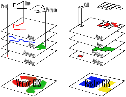 Each different theme is stored on a separate overlay. The overlays on the left represent a vector based GIS, where the information is stored as a series of points, lines and polygons. The overlays on the right represent a raster based GIS, where the information is stored as a series of discrete units called cells.
Maps in Geographic Information Systems are represented thematically. A standard topographic map will show roads, rivers, contour elevations, vegetation, human settlement patterns and other features on a single map sheet. In a GIS these features are categorized separately and stored in different map themes or overlays. For example, roads will be stored in a separate overlay. Likewise, rivers and streams will each be stored as a separate theme. This way of organizing data in the GIS makes maps much more flexible to use since these themes can be combined in any manner that is useful. The following illustration shows conceptually how maps are stored as themes in a GIS.
Each different theme is stored on a separate overlay. The overlays on the left represent a vector based GIS, where the information is stored as a series of points, lines and polygons. The overlays on the right represent a raster based GIS, where the information is stored as a series of discrete units called cells.
C) The Relation between Vector Spatial Location and Attribute Data Base
-
Each Spatial Layer is consist of many Spatial features
-
Each Spatial Feature consist of many vertexes (x, y, z)
-
Each Spatial Layer is related to one Attribute Data Base Table
-
Each Spatial Feature is related to one Attribute Data Base Record
-
Each Record consist of many fields (up to 255)
- Each Spatial Layer is consist of many Spatial features
- Each Spatial Feature consist of many vertexes (x, y, z)
- Each Spatial Layer is related to one Attribute Data Base Table
- Each Spatial Feature is related to one Attribute Data Base Record
- Each Record consist of many fields (up to 255)
D) GIS Shape File types 2D & 3D (Point – Polyline – Polygon)
-
Shp file contain spatial Location data of each feature Which are:-
-
Type 2D & 3D (Point – Polyline – Polygon)
-
Number of Parts
-
Number of Vertexes
-
X,Y, and Z of each vertex
-
Dbf file contain Attribute Data
-
Each Attribute Data table consist of many records
-
Each record consist of many fields (up to 255)
-
Shx file is a relation file between the Shp file and Dbf fie
-
Point Layer consist of one vertex per Feature(x, y, z)
-
Polyline Layer consist of many vertexes per Feature
-
Polygon Layer consist of many vertexes per Feature and closed
- Shp file contain spatial Location data of each feature Which are:-
- Type 2D & 3D (Point – Polyline – Polygon)
- Number of Parts
- Number of Vertexes
- X,Y, and Z of each vertex
- Dbf file contain Attribute Data
- Each Attribute Data table consist of many records
- Each record consist of many fields (up to 255)
- Shx file is a relation file between the Shp file and Dbf fie
- Point Layer consist of one vertex per Feature(x, y, z)
- Polyline Layer consist of many vertexes per Feature
- Polygon Layer consist of many vertexes per Feature and closed
2) Coordinates Systems
A) Lon and Lat Geographic Coordinate System
The geographic latitude (abbreviation: Lat., or phi) of a point on the Earth's surface is the angle between the equatorial plane and a line that passes through that point
The North Pole is 90° N; the south pole is 90° S. The 0° parallel of latitude is designated the equator, the fundamental plane of all geographic coordinate systems. The equator divides the globe into Northern and Southern Hemispheres.
The Longitude (abbreviation: Long., or lambda) of a point on the Earth's surface is the angle east or west from a reference meridian to another meridian that passes through that point.
All meridians are halves of great ellipses (often improperly called great circles), which converge at the north and south poles.
B) Universal Transverse Mercator Coordinate System UTM
The UTM system divides the surface of Earth between 80°S and 84°N latitude into 60 zones, each 6° of longitude in width and centered over a meridian of longitude. Zone 1 is bounded by longitude 180° to 174° W and is centered on the 177th West meridian. Zone numbering increases in an easterly direction.
Each of the 60 longitude zones in the UTM system is based on a transverse Mercator projection, which is capable of mapping a region of large north-south extent with a low amount of distortion. By using narrow zones of 6° (up to 800 km) in width, and reducing the scale factor along the central meridian by only 0.0004 to 0.9996 (a reduction of 1:2500), the amount of distortion is held below 1 part in 1,000 inside each zone. Distortion of scale increases to 1.0010 at the outer zone boundaries along the equator.
C) Converting Coordinates Between Lon Lat and UTM
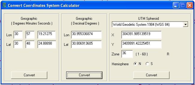 Converting Coordinates System Calculator
Converting Coordinates System Calculator
D) Map Projection
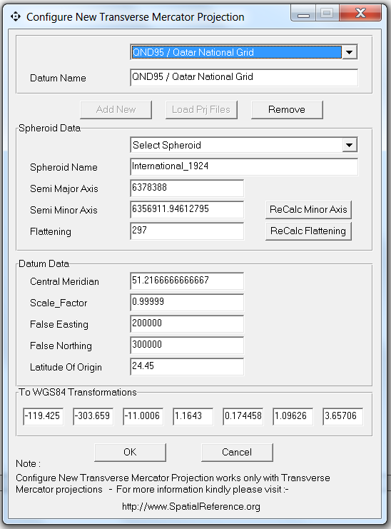 Configuring new Projection System
Menu → Tools → Configure New Projection System
Configuring new Projection System
Menu → Tools → Configure New Projection System
-
Load Projection File
-
Add
-
Remove
-
Semi Major Axis
-
Semi Minor Axis
-
Flattening value
-
Central Meridian
-
False Easting
-
False Northing
-
Latitude of Origin
-
To WGS84 Transformation
-
http://www.SpatialReference.org
-
Predefined Spheroid
-
AA Airy 1930
-
AN Australian National
-
BR Bessel 1841 Ethiopia Indonesia Japan Korea
-
BN Bessel 1841 Nambia
-
CC Clarke 1866 (NAD 1927)
-
CD Clarke 1880
-
EB Everest Brunei & E. Malasia (Sabah & Sarawak)
-
EA Everest India 1830
-
EC Everest India 1956
-
EF Everest Pakistan
-
EE Everest W. Malasia and Singapore 1948
-
ED Everest W. Malasia 1969
-
RF Geodetic Reference System 1980 (NAD 1983)
-
HE Helmert 1906
-
HO Hough 1960
-
ID Indonesian 1974
-
IN International 1924
-
KA Krassovsky 1940
-
AM Modified Airy
-
FA Modified Fischer 1960 (South Asia)
-
SA South American 1969
-
WD World Geodetic System 1972 (WGS 72)
-
WE World Geodetic System 1984 (WGS 84)
Configuring new Projection System
Menu → Tools → Configure New Projection System
- Load Projection File
- Add
- Remove
- Semi Major Axis
- Semi Minor Axis
- Flattening value
- Central Meridian
- False Easting
- False Northing
- Latitude of Origin
- To WGS84 Transformation
- http://www.SpatialReference.org
- Predefined Spheroid
- AA Airy 1930
- AN Australian National
- BR Bessel 1841 Ethiopia Indonesia Japan Korea
- BN Bessel 1841 Nambia
- CC Clarke 1866 (NAD 1927)
- CD Clarke 1880
- EB Everest Brunei & E. Malasia (Sabah & Sarawak)
- EA Everest India 1830
- EC Everest India 1956
- EF Everest Pakistan
- EE Everest W. Malasia and Singapore 1948
- ED Everest W. Malasia 1969
- RF Geodetic Reference System 1980 (NAD 1983)
- HE Helmert 1906
- HO Hough 1960
- ID Indonesian 1974
- IN International 1924
- KA Krassovsky 1940
- AM Modified Airy
- FA Modified Fischer 1960 (South Asia)
- SA South American 1969
- WD World Geodetic System 1972 (WGS 72)
- WE World Geodetic System 1984 (WGS 84)


Infant car seat weight limit
ReplyDeleteShoulder strap position
Best booster seat
Excellent blog I visit this blog it's really awesome.The important thing is that in this blog content written clearly and understandable
ReplyDeleteOnline invoicing software